

This Icelandic guy has a YouTube channel with great 4K drone footage of the area (and the rest of Iceland).
He is (obviously) doing a lot of coverage in this area currently and has some snippets of info from Icelandic Volcanologists that may not be available elsewhere.
I don’t know about you but I want to get on my bmx and launch over that crack!
🤖 I’m a bot that provides automatic summaries for articles:
Click here to see the summary
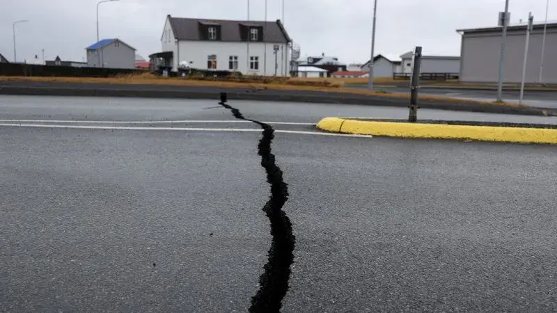
Iceland has declared a state of emergency and more than 3,000 residents have been urged to evacuate the small, coastal town of Grindavík as the country’s authorities anticipate the imminent eruption of a volcano in its southwestern peninsula.
A 15-kilometer- (nine-mile-) long magma corridor now stretches from just northwest of Grindavík into the Atlantic Ocean, according to the Civil Protection Agency, which used models built from data collected in the area on Saturday.
After scientists said they couldn’t rule out the magma tunnel reaching Grindavík, the Civil Protection Agency evacuated the town on Friday night, though some residents were allowed back to one area on Sunday under police escort to retrieve pets and essential items.
The famous Blue Lagoon, a geothermal spa about seven kilometers (four miles) north of Grindavík that draws tourists to its steaming water, closed on Thursday as a precaution.
About 100,000 flights were canceled, affecting 2 million people, as a result of the ash spewed out by the 2010 eruption, which threatened to stall aircraft engines and cause electrical failure.
Iceland sits on a tectonic plate boundary that continually splits apart, pushing North America and Eurasia away from each other along the line of the Mid-Atlantic Ridge.
Saved 80% of original text.
